Category Astronomy/Space

Mapping Martian Meteorites: Tracing Origins on the Red Planet

Mapping Martian meteorites: U of A researchers trace origins on the Red Planet
Location of the crater candidates for the ejection sites of martian meteorites. Credit: Science Advances (2024). DOI: 10.1126/sciadv.adn2378

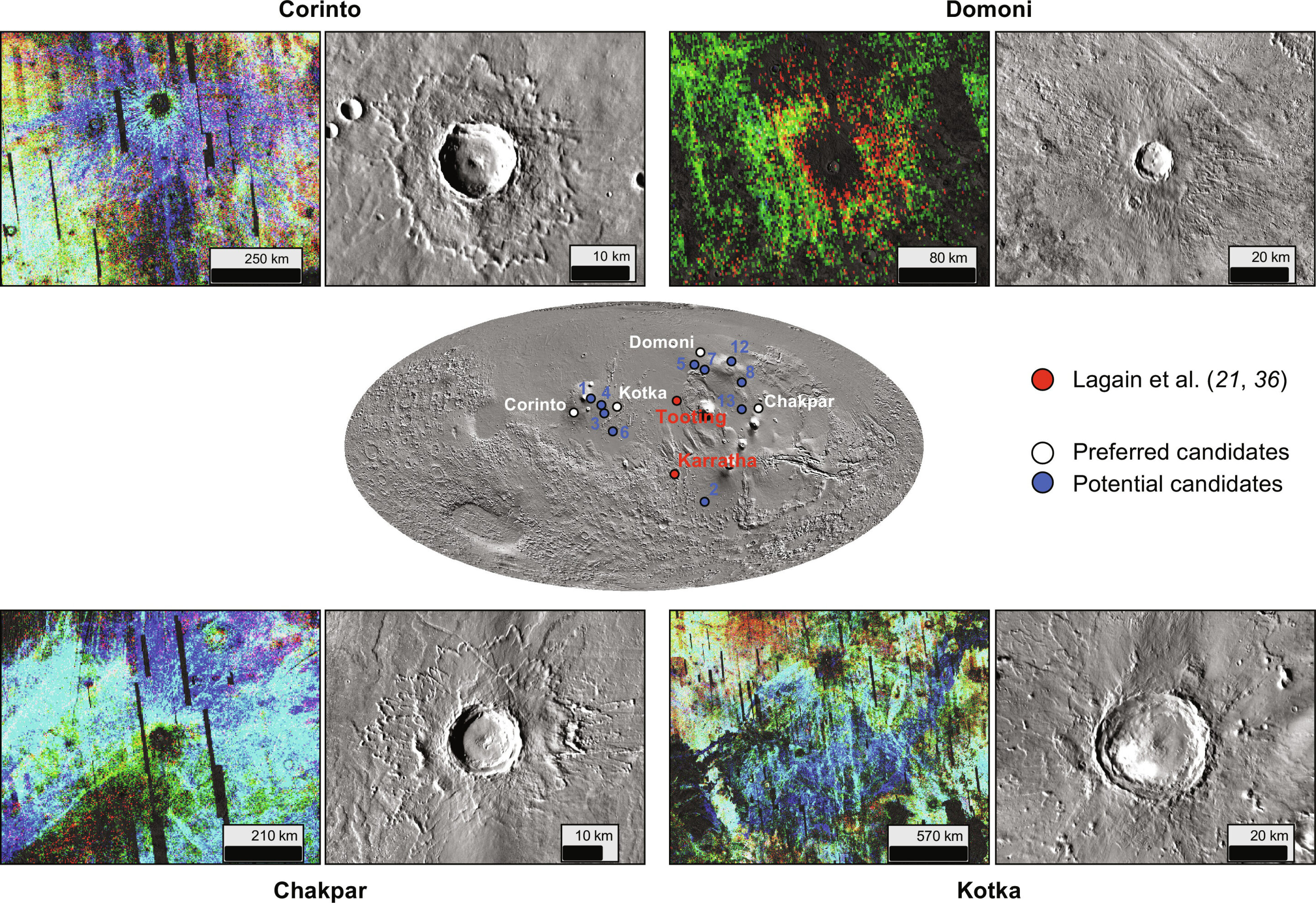
Researchers have identified the specific locations from which most of the approximately 200 Martian meteorites originate. They’ve traced the meteorites to five impact craters within two volcanic regions on the red planet called Tharsis and Elysium. Their study was published recently in the journal Science Advances.

Martian meteorites find their way to Earth when something hits the surface of Mars hard enough so that material is “blasted off the surface and accelerated fast enough to leave Mars’ gravity,” says Chris Herd, curator of the U of A’s Meteorite Collection and professor in the Faculty of Science...

Read More

Scientists Discover Phenomenon Impacting Earth’s Radiation Belts

Scientists discover phenomenon impacting Earth's radiation belts
This graphic shows a cutaway model of Earth’s radiation belts with the two Van Allen Probes satellites flying through them. Credit: NASA illustration

Two University of Alaska Fairbanks scientists have discovered a new type of “whistler,” an electromagnetic wave that carries a substantial amount of lightning energy to the Earth’s magnetosphere.

The research is published today in Science Advances.

Vikas Sonwalkar, a professor emeritus, and Amani Reddy, an assistant professor, discovered the new type of wave. The wave carries lightning energy, which enters the ionosphere at low latitudes, to the magnetosphere. The energy is reflected upward by the ionosphere’s lower boundary, at about 55 miles altitude, in the opposite hemisphere.

It was previously believed, the authors write, ...

Read More

Research Team releases a 76 m-per-pixel Global Color Image Dataset and Map of Mars

A 76m per pixel global color image dataset and map of Mars by Tianwen-1 has been released

Remote-sensing images of Mars contain rich information about its surface morphology, topography, and geological structure. These data are fundamental for scientific research and exploration missions of Mars. Prior to China’s first Mars exploration mission, data from six advanced optical imaging systems of different missions in the Martian orbit was used to generate Mars global/near-global image datasets with spatial resolutions better than 1 km.

However, in terms of global color images, the best version of Mars Viking Colorized Global Mosaic has a resolution of approximately 232 m/pixel. There is a lack of global color images of Mars at the hundred-meter scale and higher resolution.

New data obtained by the Tianwen-1 mission has laid the foundation for the development of a high-...

Read More

Engineers Conduct First In-Orbit Test of ‘Swarm’ Satellite Autonomous Navigation

With 2D cameras and space robotics algorithms, astronautics engineers have created a navigation system able to manage multiple satellites using visual data only. They just tested it in space for the first time.

Someday, instead of large, expensive individual space satellites, teams of smaller satellites — known by scientists as a “swarm” — will work in collaboration, enabling greater accuracy, agility, and autonomy. Among the scientists working to make these teams a reality are researchers at Stanford University’s Space Rendezvous Lab, who recently completed the first-ever in-orbit test of a prototype system able to navigate a swarm of satellites using only visual information shared through a wireless network.

“It’s a milestone paper and the culmination of 11 years of effort by ...

Read More