


A new study by Brown University researchers may help redefine how scientists map the surface of the Moon, making the process more streamlined and precise than ever before.
Published in the Planetary Science Journal, the research by Brown scholars Benjamin Boatwright and James Head describes enhancements to a mapping technique called shape-from-shading. The technique is used to create detailed models of lunar terrain, outlining craters, ridges, slopes and other surface hazards. By analyzing the way light hits different surfaces of the Moon, it allows researchers to estimate the three-dimensional shape of an object or surface from composites of two-dimensional images.
Accurate maps can help lunar mission planners to identify safe landing spots and areas of scientific interest, making mission operations smoother and more successful.
“It helps us piece together a better idea of what is actually there,” said Boatwright, a postdoctoral researcher in Brown’s Department of Earth, Environmental and Planetary Sciences and lead author of the new paper. “We need to understand the surface topography of the Moon where there isn’t as much light, like the shadowed areas of the lunar south pole where NASA’s Artemis missions are targeting. That will allow autonomous landing software to navigate and avoid hazards, like large rocks and boulders, that could endanger a mission. For that reason, you need models that map the topography of the surface at as high a resolution as possible because the more detail you have, the better.”
The process to develop precision maps, however, is labor intensive and has limitations when it comes to complex lighting conditions, inaccurate shadow interpretation and handling terrain variability. The Brown researchers’ improvements to the shape-from-shading technique focuses on addressing these issues.
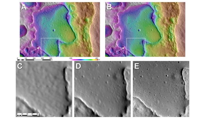
The scholars outline in the study how advanced computer algorithms can be used to automate much of the process and significantly heighten the resolution of the models. The new software gives lunar scientists the tools to create larger maps of the Moon’s surface that contain finer details at a much faster pace, the researchers say.
“Shape-from-shading requires that the images that you’re using be perfectly aligned with one another so that a feature in one image is in the exact same place in another image to build up those layers of information, but current tools are not quite in a place where you can just give it bunches of images and it’ll spit out a perfect product,” Boatwright said. “We implemented an image alignment algorithm where it picks out features in one image and tries to find those same features in the other and then line them up, so that you’re not having to sit there manually tracing interest points across multiple images, which takes a lot a of hours and brain power.”
The researchers also implemented quality control algorithms and additional filters to reduce outliers from the alignment process — tools to ensure the aligned images actually match and remove images that don’t align as well. By only selecting images that end up being usable, this improves quality and takes precision down to submeter resolutions. The speed also allows for larger surface areas to be examined, increasing the production of these maps.
The researchers evaluated the accuracy of their maps by comparing them with other existing topographic models, looking for discrepancies or errors in lunar surface features. They found the maps generated using their refined shape-from-shading method were more precise compared to those derived from traditional techniques, showing more subtle features and variations of lunar surface terrain.
For the study, the researchers primarily used data from Lunar Orbiter Laser Altimeter and Lunar Reconnaissance Orbiter Camera, instruments onboard NASA’s Lunar Reconnaissance Orbiter, which has been orbiting the Moon since 2009.
The scientists plan to use their refined shape-from-shading software to produce lunar maps, and they hope others will use it in their modeling efforts, as well. It’s why they used open-source algorithms to produce the tool.
“These new map products are significantly better than what we had in exploration planning during the Apollo missions, and they will very much improve the mission planning and scientific return for Artemis and robotic missions,” said Head, a professor of geological sciences at Brown who worked in the Apollo program.
The researchers hope the new tool will add to the current interest in the science and exploration of the Moon happening at NASA and in space agencies around the world.
“There’s a wealth of information to be gained from making these types of tools accessible to all,” Boatwright said. “It’s an egalitarian way of doing science.”
The work was supported by the NASA Goddard Space Flight Center.
https://www.brown.edu/news/2024-05-29/lunar-topography


Recent Comments